 John Booth © 31 August 2014
Download this article as a pdf here here
Oh! Those mangroves. I never saw one that looked as if it possessed a decent conscience. Growing always in shallow stagnant water, filthy black mud, or rank grass, gnarled, twisted, stunted, and half bare of foliage, they seem like crowds of withered, trodden-down old criminals, condemned to the punishment of everlasting life. I can’t help if it seems fanciful. Anyone who has seen a mangrove swamp will know what I mean.1
Perhaps the most in-your-face change to the ecology of the waters of the Bay of Islands—certainly since European times—has resulted from soil and clay belonging to the land washing into the sea. The area of drying ground along sheltered shores has expanded, defined by trees whose feet are willing to tolerate salt: mangroves. It’s a perfectly natural process—but one that can become spectacularly revved-up by human doings. Sometimes the shape and nature of the shoreline have altered so much, so quickly, that the places to which as kids we were drawn—the olds sitting on the tough-blade grass above, sipping tea brewed from the thermette, watching over and reminiscing—are now mangy mangrove backwaters.
$$$$$$$$$$$$$$$$$$$$
New Zealand’s estuaries are a legacy of 6500 years ago, when rising sea levels in a world warming after the Last Glacial Maximum gradually but relentlessly inundated coastal valleys.2 Yet these estuaries are, in turn, destined to disappear, as more material is deposited from the lands above and from the sea itself in a long-winded process calibrated in centuries.3
The point is that the rate of infilling was ramped-up exponentially once humans arrived here—and particularly since the mid-1800s. For the Bay of Islands, annual sediment-deposit rates over the past 150 years have been 22-fold greater than for the last 10 000 years4, most of it coming from the land, often shallow landslides on steepish slopes after heavy downpours.5 And the average 2.4 millimetres infilling each year of the Bay, brought about by the half-million or so tonnes of silt surging down its rivers,6 can’t be masked by the mean annual sea-level rise of 1.4 millimetres.
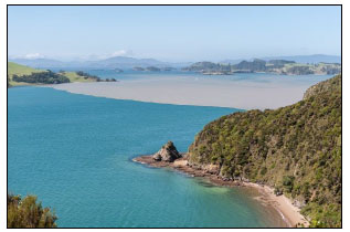
Silt-laden freshwater at the surface of the Kerikeri Inlet in standoff with clean seawater flowing down Te Puna Inlet from the left, in September 2013. (Photo: Dean Wright).
Our mangrove is a subspecies of the grey mangrove, Avicennia marina, which is found on both sides of the Equator and is one of the most widespread plants on Earth.7 A. marina subspecies australasica (in Maori, simply ‘manawa’) is the southernmost mangrove, displaying its in-built intolerance to cold by petering out near Raglan on the west coast and Ohiwa on the east. This subspecies is also found on Lord Howe Island, in New Caledonia, and along the seaboard of southeast Australia.7
Mangroves are part and parcel of our natural heritage and their expansion in the Bay of Islands can in good measure be attributed to shores silting up. Sediment deposited on sheltered shores allowed mangrove propogules to take root and seedlings establish in areas that were once too deep for them or which weren’t muddy enough. In turn, the mangroves changed the nature of the intertidal themselves, trapping fine sediment and further increasing the area of habitat suitable for colonisation and growth. And on it went.
So what has been the progression of mangrove expansion in the Bay of Islands? Were the areas of mangrove the first Europeans encountered carbon-copies of what the first Polynesian settlers explored, or had the cover already changed? And what exactly happened once the European settlers had become so successful with their own sediment-generating activities?
To address these questions, we have available to us dated cores of sediment, early written accounts and maps and charts, and recent plans and aerial photographs.
The sediment cores, with layering as potent as that of grand canyons, allow us to step back thousands of years to reach an understanding around the nature of land cover—and the impact of humans upon it. The handful of local land-cores show that the early Polynesian settlers had had devastating impact on the vegetation of the Bay of Islands and its surrounds.8 The core taken at the Wharau Road Swamp near the entrance to the Kerikeri Inlet shows that in about 1400 there was a sharp decline in trees and shrubs, accompanied by large increases in herbs and ferns.9 The story was similar for Jack’s Lake near Waitangi, 8 and Rangihoua. 9 Vast tracts of forest had been cleared, presumably for agriculture, travel, hunting and settlement—and also to promote the growth of bracken (Pteridium esculentum), a key source of starch for the settlers. By the time Europeans started turning up, about the only fully forested area remaining was in the southeast of the Bay.
And the 23 marine sediment cores scattered around the Bay of Islands showed that these land clearances certainly did result in increased sedimentation rates in the receiving estuaries.10
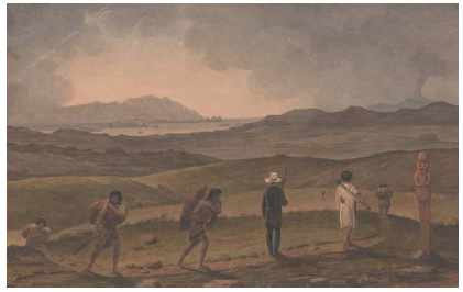
Augustus Earle’s 1827 Distant view of the Bay of Islands, from the road between Te Waimate and Haruru, with the high point of Mataka in the far left centre and Rakaumangamanga in the distant far right, suggests—as do many early accounts—a landscape largely bereft of bush.
$$$$$$$$$$$$$$$$$$$$
All else being equal, this heightened rate of silting can be expected to have led to concomitant expansion in the mangroves. I hoped that early European plans would provide a benchmark from which to look both back and forward regarding the extent of the mangrove cover.
Thomas Florance was one of New Zealand’s first professional surveyors, beautifully executing land titles and forever venerated by a street in Russell named for him. He advertised himself in Kororareka’s The New Zealand Advertiser, New Zealand’s first weekly rag, as a ‘hydrographic and land surveyor’.11 In the 20 August 1840 issue he told the town he would publish ‘A survey of the “Bay of Islands” ’ providing 50 subscribers each came to the party with £2. To have been both a chart as well as a map of the features of the shores and associated lands of the entire Bay—just what the doctor ordered for these writings—the work seems not, alas, to have been completed. Perhaps two quid (around $250 today) was just too much for punters.
Nevertheless T. Florance was helpful because in his 1836 survey of Te Wahapu Point he categorically showed mangroves growing right where we find them today, with no evidence of expansion having taken place over the intervening 170 years.
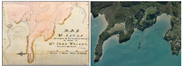
Areas marked by tufts of foliage at the heads of the embayments on each side of Te Wahapu Point (orientated east-west) are labelled ‘Mangrove Flat’ in Thomas Florance’ 1836 survey (left).12 The mangrove footprint has changed little to this day—even to the kink in the treeline in Wahapu Bay (right).13
Other early plans show the extent of mangroves early in the piece in the Bay of Islands too. But unfortunately, although insightful for particular spots, they cover only a fraction of our shores and so are of limited value in either hindcasting or forecasting the mangrove cover of the Bay. All that can be said is that areas depicted with mangroves in the mid-1800s retain them to this day, essentially with the same footprint.
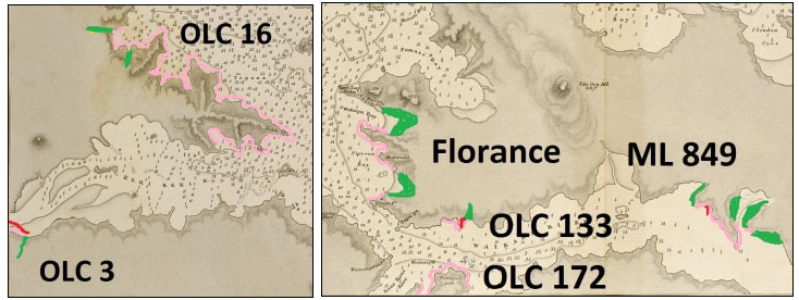
Old land claims (OLC), and a Maori Land title (ML) and the Florance survey, from the early to mid-1800s for Te Puna and Kerikeri Inlets (left) and Veronica Channel and Waikare Inlet (right), superimposed on the 1849 Acheron chart, show not only where mangroves were explicitly indicated as being present (green), but also where they are very unlikely to have been because they appear to have been explicitly omitted (pink). The extent of mangrove cover at these places has changed little to this day (three red lines). Depths are in fathoms, with contours at 1 and 3 fathoms.
$$$$$$$$$$$$$$$$$$
It wouldn’t be until 1942, with inch-to-the-mile plans, that the distribution of mangroves for the Bay would be made clear for the first time in any comprehensive manner. Shores with mangroves present were marked with what appear as pretty little green, three-leafed clovers. But they were not explicit concerning the extent of cover or average tree-size.
Soon after, a series of synoptic aerial photographs began, repeated every decade or so, from which the detail of change in mangrove cover can be discerned.14 And the pattern of the picture painted is dramatic.
By the early 1950s a line of attacking trees had established below high-tide level along many of the sheltered soft-sediment shorelines in the Bay of Islands, denoted in the aerial photographs by a spotty flanking row or two of scout trees.
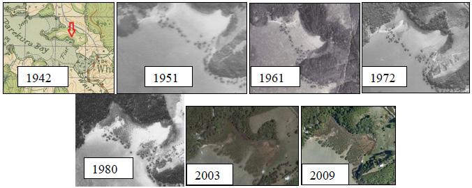
The predominant pattern of expansion for mangroves throughout the Bay of Islands over the past 60 years has been landward, not downshore or alongshore. This example, an embayment in Parekura Bay, contained mangroves in 1942 (marked with arrow), presumably essentially the same line of trees we see there in 1951. Rapid infilling of new recruits took place in the late 1970s to the 1990s, but the first individual trees remain discernible.
It may have appeared like a military manoeuvre, but the mangroves were simply opportunists. And there is no turning back, for today—almost everywhere—that wave has consolidated, invasion complete. Almost without exception expansion was shoreward, really getting up steam after 1970. And there has been virtually no new recruitment of mangroves lower on the shore since that onslaught visible in the 1950s.
Grazing of mangroves by stock on upper shores during the 1950s to 1970s, leaving just a lick of them lower down the beach, doesn’t really cut the mustard as an explanation for the changes in mangrove cover. Not in a single possie in the Bay of Islands could the shadow of a stock-grazed upper shore be discerned in the dozens of aerial photographs examined.
The landward advance of mangroves has been slow and inexorable for many sheltered shores around the Bay of Islands. What used to be swimming beaches are now mangrove habitat; shellfish beds have been forced elsewhere; and in places the oioi saltmarsh that lives higher on the shore has turned into mangroves too.
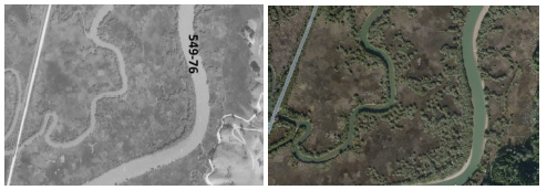
The olive-green stripe of mangroves lining the edges of these tidal reaches of Karetu appears thicker and more continuous in 2009 (right)13 than it did in the early 1950s (left)14, but perhaps more pernicious is the advance of mangroves into the oioi saltmarsh habitat.
$$$$$$$$$$$$$$$$$$
The most noticeable features of the mangrove habitats of the Bay of Islands in the early 1950s, derived from the aerial photographs, are as follows:
- There were reasonably extensive areas of large (and almost certainly old) trees associated with tidal creek and river mouths, the largest trees occupying the seaward fringes (I take these to be mangrove areas present at the beginning of colonisation; and probably from the beginning of time.)
- There were also reasonably extensive areas or bands of trees on a few of the inlet and river flats, the largest individuals occupying the seaward fringes (Again, these are long-established trees.)
- On many sheltered, soft-bottom shores otherwise free of mangroves, one row (sometimes up to three) of trees had established well below highwater level
- In a few places, similar rows of new trees had established seaward of bands of older trees
- Almost everywhere, all trees mentioned above remain the lowest on the shore
The precise mechanism to explain the pattern of recruitment of mangroves evident in the mid-1900s onwards in the Bay of Islands is far from clear.
First, why, almost always, did just a narrow line of trees establish so far below high-water level? Perhaps conditions shoreward of the line were unsuitable at the time for propogules to take root because the sediment was too sandy or too shelly. And there was always going to be a depth limit: young mangroves simply won’t tolerate too much immersion. But the zone of survival (if not recruitment) was so knife-edge.
Many of the individual mangroves (most of which are still discernible to this day) that formed this menacing line were, in the early 1950s, already quite large trees, and probably decades old. And most appeared to be of similar size, suggesting they had set up shop at about the same time.
So, what might have happened around a century ago (give or take a decade or three) that could have led to this pattern of mangrove colonisation?
It may be no coincidence that National Institute of Water and Atmospheric Research’s Andrew Swales and collaborators4 revealed in their marine sediment cores a layer of silt which they concluded had resulted from catastrophic rainstorm events and/or huge swells that had likely occurred in the Bay of Islands about 1900. Trawling through the Northland storm-event record, they came up with four candidate dates: June 1898, August 1905, March 1908, and July 1909. For the one in August 1905: ‘the old British residency [Treaty House] has suffered very severely, trees have been torn up by the roots, all the chimneys of the house blown down’ and ‘veranda has been blown clean away’. Shortly after, in 1916, there was a storm ‘so severe that it blew men down the Russell beach into the sea; the sea washed through the fences bordering the Strand.’ The Public Hall was smashed.15
Also, the late-1800s to early-1900s was the peak period of post-colonisation deforestation in Northland, when sediment loads increased by a factor of ten or more.4 Pastoral farming usually replaced the forests—rather than the fern and bracken that Maori had encouraged—meaning there was going to be an ongoing supply of silt to be carried down the streams.
There’s every chance that several things contrived at the one time to ensure the success of that new wave of recruitment of mangroves along kilometres of sheltered soft shore in the Bay of Islands. This ‘window of opportunity’ might have involved 1) vast volumes of soil destabilised as a result of land clearance; 2) particularly bountiful propogule production; 3) one or more exceptionally wet and fierce storms, resulting in wholesale deposition of silt on the upper fringes of beaches and embayments; 4) followed by the several weeks of calm conditions necessary for mangrove propogules to establish; and 5) then a quiescent period of years—perhaps in both propogule production as well as silt delivery and wave action—during which few further mangroves were added to the now-established line-of-recruitment.
It would be decades later, from the 1970s on, that the silt entrapped by the roots and pneumatophores of those founding trees had become sufficient to sustain the infilling of mangroves right up to the fringing saltmarsh and in some instances mother bush, a process now almost complete for much of the Bay of Islands.
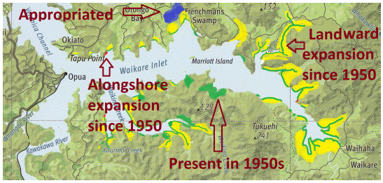
Changes in the main areas of mangrove habitat between the early 1950s and 2009 based on aerial photographs. Green represents more-or-less unchanged mangrove stands, but for greater tree-size (and are believed in these writings to essentially reflect distribution of mangroves at first European contact—and probably much earlier); yellow is significant landward expansion; and red is significant alongshore expansion. Blue is appropriated (‘reclaimed’) mangrove habitat. This pattern of mangrove expansion is replicated throughout the Bay of Islands.
In contrast to most other parts of the world—and particularly tropical regions—mangrove cover in New Zealand has expanded in recent decades.16 And, at odds it seems with most other parts of New Zealand, mangrove expansion in the Bay of Islands over the past 60 years has been shoreward, rather than downshore or alongshore. In this respect, our mangroves have behaved in a similar manner to those of the same species in southeast Australia,16 where mangrove expansion has often been at the expense of saltmarsh.
$$$$$$$$$$$$$$$$
We’ll probably never be categorical as to whether the mangroves the first Europeans encountered in the Bay of Islands were more or less what the first Polynesians had explored. But it’s my guess they essentially were. Deforestation by Maori certainly had led to more silt flowing into the sea, as the sediment cores revealed, and presumably some expansion in mangroves. But silt-runoff rates then were relatively modest compared with what followed—and continue to this day—once the land clearances in favour of pastoral farming, in particular, had taken place.
Mangrove cover in the Bay of Islands in the 100 years following the first European arrivals would, on the face of it, appear to have changed little for it was not until towards the end of the 20th century that the lines of new recruits on the shore below long-established forests and thickets, and well as in many places previously mangrove-free, had taken full hold.
This massive expansion is now largely done and dusted; rates of growth in mangrove cover in the near future will be far more modest. It will take significant rises in sea level, or huge increases in rates of siltation, for those mangrove-expansion tempos of the 1970s to 1990s to be matched.
It has taken more than a hundred years for this chapter of mangrove expansion in the Bay of Islands to play out. Had the first signs been recognised—probably an insignificant line or two of seedlings establishing along almost every sheltered soft shore in the Bay of Islands—something could have been done. It would have taken nothing more than a quick little tug on each wee plant—not criminality back in those days.
Now, really, there’s no going back.
Oh! Those mangroves. I never saw one, save for the few now taking their leave, that appear more innocent, doing this job no one else can. Growing always in shallow water, a vibrant shield over Nature’s dark doings below. Sometimes erect and outstanding, other times gnarled and contorted, or just a tot, but ever covered in succulent foliage olive to the sky and silky silver to the water, the last guard, forever accepting graciously their glorious role in protecting frail shores from the ravages of callous forces and holding back from more delicate souls lower down the shore whatever lands seek to toss them.
I can’t help if it seems fanciful. Anyone who has seen a mangrove estuary must know what I mean.
References
1Morton, J.; Miller, M. (1968): The New Zealand sea shore. Collins Auckland.
2Swales, A. plus 3 others (2003): What happens in estuaries during floods? Water & Atmosphere 11 (1): 11-13.
3Hume, T.; Swales, A. (2003): How estuaries grow old. Water & Atmosphere 11 (1): 14-15.
4Swales, A. plus 7 others (2012): Sediment sources and accumulation rates in the Bay of Islands and implications for macro-benthic fauna, mangrove and saltmarsh habitats. Northland Regional Council.
5Nicholls, P.; Ellis, J. (2002): Fringing habitats in estuaries: the sediment-mangrove connection. Water & Atmosphere 10 (4): 24-25.
6Northland Regional Council (2012): State of the Environment Report 2012.
7Auckland Regional Council (2007): The New Zealand mangrove: review of the current state of knowledge.
8Horrocks, M. plus 6 others (2007): A Late Quaternary record of natural change and human impact from Rangihoua Bay, Bay of Islands, northern New Zealand. Journal of Coastal Research 23: 592-604.
9Elliot, M.B. plus 4 others (1997): A 4300 year palynological and sedimentological record of environmental change and human impact from Wharau Road Swamp, Northland, New Zealand. Journal of the Royal Society of New Zealand 27: 401-408.
10Swales, A. plus 3 others (2010): Chapter 4. Recent sedimentation rates (over the last 100-150 years). http://www.os2020.org.nz/
11 The New Zealand Advertiser 20 and 27 August 1840.
12 Map of ‘St Johns’ (situated in the Bay of Islands, New Zealand) the property of Mr John Wright, contents 440 acres, by Florance. 1836. Alexander Turnbull Library, Wellington. MapColl 832. 11gbbd/1836/Acc.601.
13Ocean Survey 20/20. http://www.os2020.org.nz/
14New Zealand Aerial Mapping Ltd. http://nzam.com/
15King, M.M. (1949): Port in the north. A short history of Russell. Russell Centennial Historical Committee.
16Morrissey, D.J. plus 5 others (2010): The ecology and management of temperate mangroves. Oceanography and Marine Biology. An Annual Review 48: 43-160.